The "SKYWAVE" Over the Horizon Test Array
Sources and Recommended additional reading by Dr Bob Clarke
"The Illustrated Guide To Armageddon ISBN 978-14456-0915-7"
“Four Minute Warning, Britain's Cold War ISBN 0-7524-3394-6”
Article by Chris Morshead and Vincent Povey

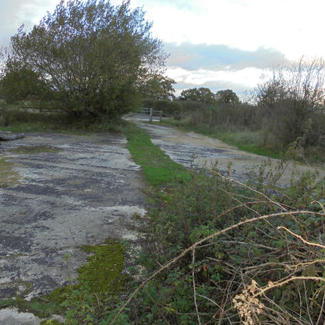
Running on an alignment of magnetic north at 350 degrees, the remains of an experimental Over The Horizon Radar (OTHR) Receiver Array can be found on the SE corner of the airfield. (Fig 1 above). Nothing remains today except a scar in the concrete running for approximately 300m from the centre of the original runway #2, through woodland, eventually breaking out onto the perimeter track remains just adjacent to the entrance to the incendiary store part of the WW2 bomb dump. The use of this Array was uncertain and, initially, it was linked to a plan in the late 1980s to site an operational Radar system at RAF Blakehill Farm – see > for details of this proposed Radar. However, subsequent research into the origins of this particular Array (Fig 2) have led to a story which goes back way before the 1980’s – right back to the 1960’s in fact! Using a system where the Radar signal is bounced off the Ionosphere (known as Skywave propagation) it become known as the "Skywave Radar". The Receiver Array (see picture below) was constructed looking into the North Atlantic. The Transmitter could either be at Blakehill Farm using another, smaller Array (when the Radar operates in what is known as Monostatic Mode - the Transmitter and the Receiver are at the same site) or with the Transmitter located at another site many miles away (when operating in Bi-static Mode - the Transmitter is located elsewhere).
Sadly, we don't know where the Transmitter Array was here at Blakehill but we do know it was used in both modes over the years.

It is clear that the facilities were used by a huge number of Research Organisations to study a wide range of phenomena, not just Military. This included such things as Oceanic Research, using this OTHR to study sea conditions (wave heights, direction of movement, speed of movement etc) out in the Atlantic Ocean beyond Ireland. The organisations included various Universities, the Institute of Oceanographic Sciences, the Meteorological Office, the Royal Signals and Radar Establishment (RSRE) based at Malvern and even the National Air Traffic Services (NATS). This work partnered, in many cases, with countries across the world – including, in some cases, the Soviet Union – and ran for many years, we think over 30 years. Clearly, partners were carefully chosen depending on the topic being studied at the time and not all “partners” would have access to the site!
Clearly, while much of the work was for Civilian organisations such as NATS and the Royal Meteorological Society and the Met Office, it is clear that a Radar tracking civil aircraft in the North Atlantic for NATS could equally be employed looking for hostile (Soviet military aircraft) operating in the same area.
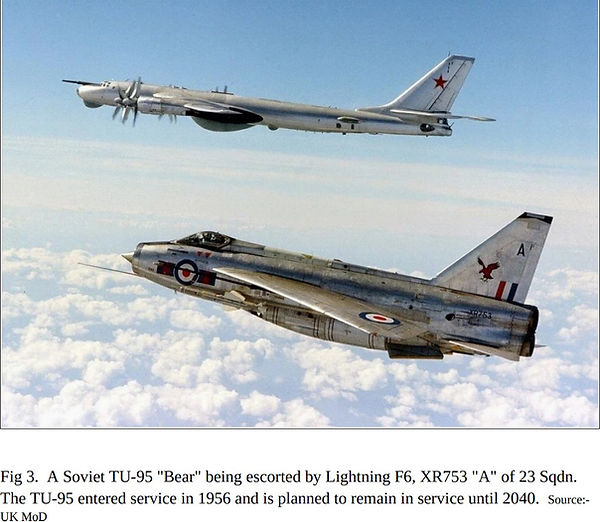
For example, Soviet aircraft such as their long-range Tupolev Tu-95 “Bear” Maritime Reconnaissance Aircraft and Bombers (see Fig 3) were known to operate spy flights in the North Atlantic and regularly flew from the North of the Soviet Union across the Atlantic to visit their friends and Allies just off the coast of the United States – Cuba.
No-one should forget the Cuban Crisis in 1962, probably one of the closest moments we got to having a World War III!

Military Radar Research at Blakehill Farm?
However, information on the use of this particular test Array for any military purposes remains Classified “Secret” and we can only guess at what it may have been used for. And this OTHR was only one of many aerials on the former Airfield. Far more experiments were carried out using all the other aerials that were installed, permanently or temporarily, at Blakehill Farm. Indeed, in 2020, further evidence came to light suggesting there was another one, possibly two, temporary, test OTHRs located on the old Airfield looking Northwards. One of these could well have provided the information to help plan for the deployment a full-scale Military Radar (which would have “looked” North in a similar direction. One was most certainly used in some Oceanic Research in 1978, the receiver array being here at Blakehill. The Transmitter for the work was initially at Corbbett Hill (near Guildford, Surrey) but, later, it moved to RAF Greatworth (near Banbury, Oxfordshire).


There is also a building which still exists today, now known as the Whitworth Building, close to the site of the Array (Fig 4a). While we don't know when it was built, it is very likely that this was used to house the receiving and signal processing equipment associated with any experiments using the Array or, indeed, other equipment on that part of the site. When the site closed down, this building was full of special cones used to absorb Electronic signals. This is known as RAM (or Radar Absorbent Material) and is used to prevent unwanted radio/radar signals upsetting any experiments and is commonly found in research facilities. Again, when this RAM was fitted is unknown as it was probably fitted for the last experiments carried out in the building and remained up until Wiltshire Wildlife took over the site. Sadly all of the RAM was disposed of but we do have a photo of some of the RAM in the building (Fig 4b)
How much of the arrary remains today?
Like much of the former air station, so much has now been removed or has returned to nature, it is difficult for the causal visitor to appreciate the remains from ground level.
What remains is around a 1000 metre long trench that has been back-filled with gravel and concrete and is mostly obscured by trees. Boxes made from fibre-glass containing the switching gear to steer the beam from the antenna to the target were situated along this line with a robust power supply running to the array. The bases of these boxes remain. One source has described a 100kW short wave transmitter glowing in the gloom within the receiver building and then a screened room with a computer processing the data. Stumps of posts remain mostly identifiable on the farm yard section (PRIVATE LAND) and are located 15m away from the central trench, spaced around 6m apart. There is another feature known as the 'Plunger' which requires further investigation.
The Whitworth Building

From the remaining southern extremity of the scar (at least as far as one can venture due to vegetation) the scar runs on an alignment of 350 degrees across the farm yard, the first section covers 48m until reaching a pair of steel upright rods which are within an area of bramble. These were possibly metal conduits.
Following on from this feature, the scarring extends for another 59m, crossing the original runway centreline before reaching the next obstacle, one of the equipment barns belonging to the WWT. Measured from the rear elevation of the barn, the scar then travels for another 53m before being lost again in undergrowth.
At the next available point of reference (ON PRIVATE LAND LOCKED AND GATED) the scar clears from the woodland to cross a disused spectacle dispersal, finally appearing out onto the remaining perimeter track. The remains of one of the “equipment box” hard standings is evident.

Sadly, that is all that remains of this once considerable structure. One thing is for certain – this Blakehill Farm OTHR Test Array was used for many, many purposes, many entirely peaceful but, quite possibly, for some for Secret Military purposes.
The end of the Cold War in 1991 signalled a great reduction in Military work and the site was eventually closed down in the mid-1990's and all equipment was removed from the site. Today, nature is taking over once again.

The extreme northern end of the scar ends with the filled in gravel trench and the remains of a mast - below


The site looking south today, compared to as it was during its operation - below gallery of remains
PRIVATE LAND NO ACCESS


